
A Battle Near Fort Amanda?
Back in the 70's I came across correspondence from General Anthony Wayne to the Secretary of War (1793-96) that caused me to believe that Wayne built a fort on the site of what would later become Fort Amanda. After careful study of the letters, I wrote a paper outlining my rationale for proposing that Wayne did indeed build a post of some kind on the site and named it "Head of Auglaize." The paper is housed in the Great Lakes Research Center at Bowling Green University. I posted that paper here in Feb. 2019. At the time I wrote my first paper, I was focused almost entirely on the fort issue and in doing so overlooked something very interesting in a letter Wayne wrote on January 8, 1793. In that letter he mentioned that a group his men had engaged in a fight with a group of Indians and that his men returned to camp returned to camp "the next day," the key words being "next day." Studying that letter more carefully and taking into consideration cause and effect factors, I'm led to believe that a fight between a small contingent of Wayne's troops and hostile Indians may have taken place in or very near Tawa Town (Fort Amanda Rd.) on January 2, 1793.
The following is a chronology of events that led supports a battle theory along with new information that supports my original proposal that Wayne did indeed build a structure on the site of what later became Fort Amanda.
Like any claim, proposal, hypothesis, or best guess, they can be proven 100% correct or 100% wrong and anywhere in between. The following is the rationale I used regarding a battle at Tawa Town, and because I don't know what I don't know. Its been said when you make a bold claim like I'm making it should be supported by "compelling evidence" that supports it. Hence the reason for the mind numbing number of details. Yes, I am sticking my neck out on this one however it is is true, it could add a new chapter in the history of early Allen/Auglaize Counties. And if my "best guess" is proven wrong, that's OK, helps me sharpen my research skills. :-)
Setting the Stage
During a 10 year period 1780 - 1790 approximately 1500 settlers living north of the Ohio River had been murdered by Indians. In response, President George Washington sent two armies into the Ohio country to destroy a group of Miami villages at a place called Kekionga, capital of the Miami tribe. It was a sprawling complex made up of several villages located at the confluence of the Saint Joseph, Saint Marys and Maumee rivers (Fort Wayne, Ind).

The first campaign was led by General Josiah Harmar in 1790 and the second by General Arthur St. Clair) in 1791. Both ended in complete disasters. The latter, known as St. Clairs defeat, (Fort Recovery, Oh.) resulted in the loss of 1/4 of the entire United States Army massacred in a battle lasting less than 3 hours.

Global Concerns
The defeat of two major military campaigns at the hands of the hostile Indian tribes raised the stakes considerably higher in terms of national security. Not only was there a major concern with the continuing Indian hostilities in the northwest, there was an equally growing concern that the disastrous campaigns of Harmar and St. Clair could create the impression that the United States was weak and incapable of dealing not only with her internal problems with the Indians, but equally incapable of defending herself against foreign powers as well. This was a major concern for President Washington.
In the Spring of 1792 Washington called on one of his most trusted Revolutionary War generals, 47-year-old Anthony Wayne to come out of retirement, assume command of the Army of the Northwest and lead an army into the Ohio country to put an end to the atrocities occurring there. General Wayne agreed. He created a camp near 20 miles northwest of Pittsburgh, Pa. and named it "Legionville." He spent the winter of 1792-93 there training his men on marksmanship and battle tactics. Today Legionville is considered the first army basic training facility in the U.S.
On March 31, 1793 Wayne and his troops loaded onto boats and began their six day, 464 mile journey to Fort Washington in Cincinnati. Arriving in Cincinnati on April 5th, Wayne discovered that there was not enough open between the fort and the Ohio River for his encampment. In addition, the General felt that the area was too close to the lure of the temptations of the nearby village of Cincinnati with, “its ardent poison and caitiff wretches to dispose of it.” He decided the best and least distracting area for an encampment was on an area of high ground a mile west of Fort Washington. He named the site Hobson ’s Choice. Webster’s dictionary describes Hobson’s Choice as, “an apparently free choice when there are no alternatives.” The site today is at the intersection of Gest and west. 6th Sts. in Cincinnati.

In September of 93, Wayne moved north 70 miles where he halted and built the largest wooden fort ever built in North America. He named it Greenville.

Kekionga (1791) Kekionga (Today)
The first campaign was led by General Josiah Harmar in 1790 and the second by General Arthur St. Clair) in 1791. Both ended in complete disasters. The latter, known as St. Clairs defeat, (Fort Recovery, Oh.) resulted in the loss of 1/4 of the entire United States Army massacred in a battle lasting less than 3 hours.
Global Concerns
The defeat of two major military campaigns at the hands of the hostile Indian tribes raised the stakes considerably higher in terms of national security. Not only was there a major concern with the continuing Indian hostilities in the northwest, there was an equally growing concern that the disastrous campaigns of Harmar and St. Clair could create the impression that the United States was weak and incapable of dealing not only with her internal problems with the Indians, but equally incapable of defending herself against foreign powers as well. This was a major concern for President Washington.
In the Spring of 1792 Washington called on one of his most trusted Revolutionary War generals, 47-year-old Anthony Wayne to come out of retirement, assume command of the Army of the Northwest and lead an army into the Ohio country to put an end to the atrocities occurring there. General Wayne agreed. He created a camp near 20 miles northwest of Pittsburgh, Pa. and named it "Legionville." He spent the winter of 1792-93 there training his men on marksmanship and battle tactics. Today Legionville is considered the first army basic training facility in the U.S.
On March 31, 1793 Wayne and his troops loaded onto boats and began their six day, 464 mile journey to Fort Washington in Cincinnati. Arriving in Cincinnati on April 5th, Wayne discovered that there was not enough open between the fort and the Ohio River for his encampment. In addition, the General felt that the area was too close to the lure of the temptations of the nearby village of Cincinnati with, “its ardent poison and caitiff wretches to dispose of it.” He decided the best and least distracting area for an encampment was on an area of high ground a mile west of Fort Washington. He named the site Hobson ’s Choice. Webster’s dictionary describes Hobson’s Choice as, “an apparently free choice when there are no alternatives.” The site today is at the intersection of Gest and west. 6th Sts. in Cincinnati.
In September of 93, Wayne moved north 70 miles where he halted and built the largest wooden fort ever built in North America. He named it Greenville.
Greenville
Frustrations
The latter part of December 1793, General Wayne received intelligence that Indians were beginning to gather at Grand Glaize (Defiance, Oh.). Grand Glaize was the headquarters of a multitribal confederacy made up of Shawnee, Miami and Delaware tribes supported by the British to help stop expansion into the northwest territory. The "Glaize" was made up of seven villages with a population of nearly 2000. In January he sent emissaries to the various tribes trying to convince them to come to Greenville and negotiate a peace treaty. The efforts proved fruitless. Uh Oh! I'm Going To Have To RethinkThis
A few weeks later, Wayne learned that the British, believing his army was on its way to capture Detroit, had hastily constructed a fort on the Maumee River a short distance from the mouth of Lake Erie to thwart his advance. Sensing the Indians would join forces with the British, Wayne sent an ultimatum to the tribal leaders to release all their prisoners by February 4th and come to Fort Greenville to negotiate a peace treaty or face the full force of the American army.

Plans Have Changed
Wayne’s war strategy had now changed. His initial mission was to attack and gain possession of the area of the Miami villages and now there was a real possibility that the Indians there, seeing his advance could be leaving and joining the other tribes at Grand Glaize. Wayne had marched his army hundreds of mile into the wilderness and was not about to gamble on the possibility that the only accomplishment of his campaign would be burning a few huts in an abandoned village. What he needed now was a backup strategy, one that focused on attacking and taking possession of Grand Glaize. Getting to the Miami villages would be no problem; Harmar had blazed a trail there in 1790, but the path to Grand Glaize wouldn’t be as easy.
Getting ThereTo his front was the Great Black Swamp, a glacially fed wetland 120 miles long and 40 miles wide, encompassing an area of approximately 100,000 acres and covering an area the size of Connecticut.

Getting ThereTo his front was the Great Black Swamp, a glacially fed wetland 120 miles long and 40 miles wide, encompassing an area of approximately 100,000 acres and covering an area the size of Connecticut.
The Great Black Swamp
An Alternative - The Auglaize River
An alternative to the overland route was the river system. Wayne knew it was possible to ship materials by water from the east, down the Ohio River to Cincinnati, enter the Great Miami River and float them as far north as Loramies store. To his north were the St. Mary’s and Auglaize Rivers. Auglaize returned and told him they using the river wa supplies overland from Lorames store, through the Great Black Swamp to Grand Glaize a distance of nearly 100 miles but that would be very expensive and at times very unreliable. He now turned his focus on the Auglaize river. After all, it flowed all the way to Grand Glaize. To determine the feasibility of doing so, Wayne sent a small group of soldiers to look for the best route to the Auglaize and report back on the feasibility of using it.
 There are two very interesting statements in Wayne’s letter. The first is his comment that the group was sent to the Auglaize River to “reconnoiter a position.” He knew where the Auglaize River was so he wasn’t trying to determine it’s “position” what he was looking for was a spot or location on the river he could use for a specific purpose, possibly and area where supplies could be loaded onto boats.
His second comment about the soldiers returning to Greenville, “ in the course of the next day” is even more interesting. Wayne wrote that after the fight with the Indians, the soldiers returned back to camp the next day. What this tells us is the battle site was one days ride from Greenville. The significance of that comment is that by determining how far a horse and rider can travel in a day, it should give us an idea of how far from Greenville the battle took place.
The Battle
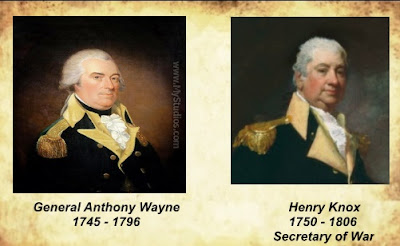
During this time General Wayne and Secretary of War, Henry Knox were in constant communications.
On January 8th, Wayne sent the following to Knox.
His second comment about the soldiers returning to Greenville, “ in the course of the next day” is even more interesting. Wayne wrote that after the fight with the Indians, the soldiers returned back to camp the next day. What this tells us is the battle site was one days ride from Greenville. The significance of that comment is that by determining how far a horse and rider can travel in a day, it should give us an idea of how far from Greenville the battle took place.
Zeroing In On The Battle Site
To answer the question several factors need to be considered
1. Typical distance a cavalry horse can travel in a day.
2. Physical condition of the horses
3. Travel speeds
4. Normal soldier “in the saddle time”
5. The weather conditions at the time
6. Obstacles
7. Available daylight.
1. While internet vary on how far a horse and rider can travel in a day but most agree on 40-50 miles assuming the horse is in good physical condition and normal weather conditions. Other factors to consider are:
2. First of all its safe to assume that the horses were in good physical condition. They were cavalry horses and used to walking long distances.
3. Most sources agree that horses travel at between 4 – 8 miles per hour. The average flat walk speed is 6 miles per hour.
4. Normal “time in the saddle” for a cavalry soldier is 8 – 10 hours
5. The assumption is that the weather in Ohio in January in 1794 was much like the weather we experience today; snow and ice. This could have had an effect on the average walking speed of the animals. The terrain from Greenville to the Auglaize is for the most part flat. The elevation at Fort Amanda is 822 feet above sea level and 1033 and Greenville; a rise of 200 feet over 45 miles. Put another way, the ground level from the Auglaize to Greenville rose about 4 ½ feet every mile. There are no large rivers to cross on the path back to Greenville so that should have had little effect on travel times.
6. Another obstacle would have been how much snow and ice would play a factor in slowing the travel speed.
7. There are approx. 9 hours of daylight in Ohio in January, the same would have been true in 1794. Leaving the area of the Auglaize at daybreak (7 a.m.) and riding for 9 hours following the same route home, the men could have arrived back at Greenville before sunset.
Artifacts Found at Tawa Town
Artifacts found at Tawa Town
A: Large caliber musket ball B: gun flint
C: buttons
D: broken knives
E: Buckles
F: pieces of brass kettle
F: pieces of brass kettle
G: trinket
H: large Frog Legged Eagle button
I: Small Frog Legged Eagle button
I: Small Frog Legged Eagle button
J: arrow head
K: bell
L: Ramrod ferrule
M: silver plated button
N: equip buckle
O: shoe or strap buckle
P: Ox bit
Q: spur
R: thin side plate
S: Large side plate
T: Button with etching
U: touch hole pick
V. ??
W: Rack for stirrup strap
X: large kettle patch with patch.
It is impossible to mark on the map above where every piece was found because on some days I found so many pieces I couldn't remember exactly where I found them in the field. Below are a few of the pieces I found in Tawa Town.
X: large kettle patch with patch.
It is impossible to mark on the map above where every piece was found because on some days I found so many pieces I couldn't remember exactly where I found them in the field. Below are a few of the pieces I found in Tawa Town.


The second week of January 1794, the second group of soldiers returned to tell Wayne that the Auglaize River was indeed navigable and the terrain between Loramies store and the Auglaize was basically level. The elevation difference between the two points is approx. 120 feet meaning the the ground rose approx. 5 feet every mile.
NOTE: Wayne’s mileage estimates are based on “as the crow flies” not actual land or river miles.
Wayne estimated the distance from the Great Miami River at Loramie's store (Fort Loramie, Oh.) to the Auglaize River was between 18-20 miles. In his May 7, 1794 letter he changed the estimated to 21 miles. The actual straight line distance from Loramies to the Tawa Town is 22 miles.


Wayne's Fort - "Head of Auglaize"
General Wayne went on to win the battle of Fallen Timbers on Aug. 20th, 1794. When he returned to Fort Greenville he once again began to focus on the Auglaize River. During negotiations with the Indians the following year, the area of Fort Amanda along with several other sections of land were ceded to the United States.


The Jay Treaty gave the British fort (Fort Miami) to the United States. Wayne could move his materials overland from Loramies store to Wayne's new post, Head of Auglaize, load them onto boats and float them to either Grand Glaize (now Fort Defiance) then on to Fort Miami (now garrisoned by American troops) and even on to Lake Erie.
Tawa Town
Wayne returned to the area in the fall of 1796 during an inspection tour of the forts he had built. On August 1, 1796 while at Girtys Town (St. Marys) He wrote the officer in charge to supply the Indians at Tawa Town with provisions. 
Last ThoughtDuring the battle on January 2, 1793, three of Wayne's soldiers and five Indian warriors were killed. Being January in Ohio, its doubtful the dead were buried. If what I've written is correct, Tawa Town isn't just a field, or an abandoned Indian village, it's hallowed ground.
Conclusion
Whether Fort Head of Auglaize was a fortified military installation or simply a series of blockhouses meant for storage will probably always remain a mystery. The same with whether or there was a battle at Tawa Town. However it is difficult to ignore the question of why there were so many pieces of military equipment, ie, spur, gun parts, ramrod ferrule, touch hole pick, spent musket balls, bayonet, and especially the 2 Frog Legged Eagle buttons worn the uniforms of Waynes troops during his campaign. Regardless of whether history proves me right or wrong, the search for truth has been a lot of work, a lot of fun and as always, a labor of love.