McKee's Hill
New Questions.

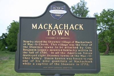
 This attack was one of a series of attacks leveled on the Indian villages in the area.
Following mistreatment by the settlers, he left the Americans in favor of the British at Detroit. It was during this transition that he established his well-known association with Matthew Elliott and the Girty brothers: Simon, James, and George.
During the next 25 years, Alexander McKee led efforts to promote the alliance of the Indians with the British, most especially with the Shawnee, but also with the majority of the Northwest Indian tribes. He guarded the interests of the Indians and was their honest friend. The Continental Congress branded him a traitor for remaining loyal to the British Empire and organizing several tribes on the side of the British.
Now I have to admit, whenever I'd think about McKee, I'd always visualize him as a scraggly looking, tough talking, tobacco chewing uncouth country bumpkin, walking around with a bag of trinkets and beads to swap with the local Indians, but the more I read about him, the more I began to see him in a different light.
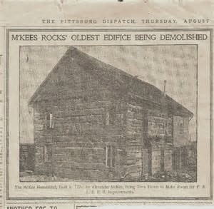
 Apparently he did well. Around 1764, McKee settled in what is now McKees Rocks, Pennsylvania where he appears to have lived a very comfortable life in his 8-room log mansion on his 1,200 acre plantation named "Fairview" located across the river from Pittsburgh, Pennsylvania. In 1770, George Washington wrote in his diary that he had dinner with McKee at Fairview, thus giving us the good impression that McKee was pretty well known among other historical figures at the time.
Now when I think of Alexander McKee, I visualize him more as a businessman in coat and tie rather than buckskins and moccasins.

If you recall from my last blog, in September of 1786, General George Rogers Clark, while at his home in Louisville, Ky. received an intelligence report that said a large number of Indians along with British agents were planning to assemble on the upper Wabash in September or October that year.

Clark immediately organized a force of 2000 militia troops and on September 10th, started north into the upper Wabash River area in present-day Indiana. Before leaving Clark had ordered Colonel Benjamin Logan to collect another militia force and to lead his force into the upper Miami River valley against the Shawnee villages as a diversionary strike. These thrusts into Indian lands were to take place at the same time, Clarks leaving Louisville and Logan's leaving Limestone, Ky, both heading directly north.
On Oct. 6, Logans force attacked the Indian village of Mackachack (east of West Liberty, Ohio).

George Rogers Clark
1752- 1818
Clark immediately organized a force of 2000 militia troops and on September 10th, started north into the upper Wabash River area in present-day Indiana. Before leaving Clark had ordered Colonel Benjamin Logan to collect another militia force and to lead his force into the upper Miami River valley against the Shawnee villages as a diversionary strike. These thrusts into Indian lands were to take place at the same time, Clarks leaving Louisville and Logan's leaving Limestone, Ky, both heading directly north.
On Oct. 6, Logans force attacked the Indian village of Mackachack (east of West Liberty, Ohio).


Alexander McKee
McKee, namesake of a little known rise of ground near Lafayette, Ohio was born about 1735 the second son of Thomas McKee an Irish immigrant (probably Scots-Irish from northern Ireland), fur trader, Indian Agent, and interpreter. His mother, Mary, was a white captive from a North Carolina settler's family who had been adopted and assimilated into the Shawnee tribe. She died when he was young. As a young man, Alexander McKee began working with traders who did business with the Indians of the Ohio Country. Soon, he was able to establish his own trading business. Because of his good relations with the Ohio tribes, Indian agent George Croghan enlisted McKee in the service of the Crown's Indian Department.Following mistreatment by the settlers, he left the Americans in favor of the British at Detroit. It was during this transition that he established his well-known association with Matthew Elliott and the Girty brothers: Simon, James, and George.
During the next 25 years, Alexander McKee led efforts to promote the alliance of the Indians with the British, most especially with the Shawnee, but also with the majority of the Northwest Indian tribes. He guarded the interests of the Indians and was their honest friend. The Continental Congress branded him a traitor for remaining loyal to the British Empire and organizing several tribes on the side of the British.
Now I have to admit, whenever I'd think about McKee, I'd always visualize him as a scraggly looking, tough talking, tobacco chewing uncouth country bumpkin, walking around with a bag of trinkets and beads to swap with the local Indians, but the more I read about him, the more I began to see him in a different light.
Now when I think of Alexander McKee, I visualize him more as a businessman in coat and tie rather than buckskins and moccasins.

Sometime after the Revolutionary War McKee left the comforts of his Fairview plantation and headed west. Why he ended up in the Shawnee village of Mackachak is unknown.

Colonel Benjamin Logan
1742 - 1802

Writers have told us for years that an Indian trader/interpreter named Alexander McKee "fled" the Mackachack village on Oct. 6 taking with him, along with his personal belongings, a drove of hogs. He eventually halted on the south bank of the Ottawa River west of Lafayette, Oh where he had to abandoned most of his hogs.
Note:
If you Google "mckees hill
historical marker" the site will give you the GPS coordinates for where
it's located.
40° 46.33′ N,
83° 57.925′ W. That is incorrect.
If you're Type in, 40° 46' 10.99" N, 83° 57' 52.10.92"W.
If you're Type in, 40° 46' 10.99" N, 83° 57' 52.10.92"W.
Its actually only 990 feet south of the internet site.

1988

1988
The more I read about this story, the more questions I had.
Question #1
"Was the Attack on Mackachack a Surprise Attack"
Question #1
"Was the Attack on Mackachack a Surprise Attack"
Could it be that Logan's attack wasn't a surprise after all? Writers tell us that there were very few men of fighting age in the village at the time of the attack. They (the Indians) knew there was a treaty and perhaps they wanted to avoid any kind of potential problem, they simply left assuming the women, children and older people would be safe. As we now know, they were not.
Question #2
Did McKee "flee" or Did He Simply Pack Up and Leave?
The obvious question is if McKee was "fleeing" from an approaching enemy, why would he slow himself down by droving a large herd of hogs? It wasn't about a food supply, he was less than a weeks trip away from the British occupied areas near Toledo. If they knew Logan was near, I doubt he'd take the time to pack up his belongings, round up his hogs, assemble a group of men to go with him then start north. This further supports the idea Logan's attack wasn't a surprise attack after all and McKee probably wasn't "fleeing" as we normally think of the word.

Question #3
Is Napoleon Rd. "The Old Black Swamp Trail?"
Partially? Ok, I realize I'm tampering with another long held tradition here, but I did find evidence that suggests that the actual "trail" in that section of Jackson Township was 1/2 mile east of Napoleon Rd.
My Visit to McKee's Hill
The first and last time I visited McKee's hill was 45 years ago (1975) so some of my memories about the site are a little cloudy. Three things remain clear in my mind; 1) there was large number of small hills and gullies in the area near the river, 2) there was a gigantic sycamore tree in the immediate area that must have been hundreds of years old and surely growing when McKee passed by and 3) I distinctly remember seeing what looked very much like a path. The ground in the area by the tree sloped slightly to the west but at one point it leveled out creating a flat area about five feet wide and looking very much like a well worn path. I also remembering hearing stories that at one time there was an old school house near the sycamore but I couldn't any remains of any structures. If what I saw was indeed a path, that could support the view that that was part of the original Black Swamp Trail at least in that section of Jackson Township. I had my metal detector with me and hoped I'd find some metal objects McKee may have abandoned but no luck. I do remember seeing some oddly placed river stones near the trail and when I dug down a few inches I found bones. I knew when people died along trails they were often buried near the trail with rocks improvised as gravestones. I couldn't tell if were animal or human but I decided it was best not to know so I covered them up and wandered on. Who knows, they could have been bones from McKee's hogs.

Yes, the Sycamoe was that large and no, that isn't me in the picture.
How did "Hog Creek" Get It's Name?
As the story goes, as McKee approached the Ottawa River he halted because the river was too dangerous to try to cross. He decided to leave a large number of his hogs behind on the south bank. Traditions say that the local Indians survived the Winter of 1786 using the hogs as their food source and out of respect they named the river "Koshko Sepe", which in the Shawnee language meant "The Creek of the Hogs" or "Hog Stream." In the following years the stream became known to locals as "Hog Crick," and not in a flattering way. Sad because the original name was much more respectful and historical.
Alexander McKee
Alexander McKee was born about 1735 the second son of Thomas McKee an Irish immigrant (probably Scots-Irish from northern Ireland), fur trader, Indian Agent, and interpreter. His mother, Mary, was a white captive from a North Carolina settler's family who had been adopted and assimilated into the Shawnee tribe. She died when he was young. As a young man, Alexander McKee began working with traders who did business with the Indians of the Ohio Country. Soon, he was able to establish his own trading business. Because of his good relations with the Ohio tribes, Indian agent George Croghan enlisted McKee in the service of the Crown's Indian Department and McKee also became a British Indian Agent.
Following mistreatment of the Indians by the settlers, he left the Americans in favor of the British at Detroit. It was during this transition that he established his well-known association with Matthew Elliott and the Girty brothers: Simon, James, and George.
During the next 25 years, Alexander McKee led efforts to promote the alliance of the Indians with the British, most especially with the Shawnee, but also with the majority of the Northwest Indian tribes. He guarded the interests of the Indians and was their honest friend. The Continental Congress branded him a traitor for remaining loyal to the British Empire and organizing several tribes on the side of the British.
McKee the Successful Entrepreneur
Apparently McKee did well in his trading business. Around 1764, McKee settled in what is now McKees Rocks, Pennsylvania where he apparently lived a very comfortable life on his plantation named "Fairview" in his 8-room log mansion located across the river from Pittsburgh, Pennsylvania.

In 1770, George Washington wrote in his diary that he had dinner with McKee at the Fairview plantation. This adds to the perception that McKee was pretty well known among other historical figures at the time. Now that I know more about the man, the less I perceive him as a scraggly looking, tough talking, tobacco chewing uncouth country bumpkin, walking around with a bag of trinkets and beads to swap with the local Indians, couldn't be further from the truth. He was a successful business man who just happened to be in the wrong side during a war.

In 1770, George Washington wrote in his diary that he had dinner with McKee at the Fairview plantation. This adds to the perception that McKee was pretty well known among other historical figures at the time. Now that I know more about the man, the less I perceive him as a scraggly looking, tough talking, tobacco chewing uncouth country bumpkin, walking around with a bag of trinkets and beads to swap with the local Indians, couldn't be further from the truth. He was a successful business man who just happened to be in the wrong side during a war.
McKee died in Canada at the age of 64 on January 15, 1799 a His old friend Georgce Washington died later that same year on December 14th. McKee was mourned and greatly honored by the Northwest tribes and his son Thomas McKee was a Canadian soldier who went on to become a popular political figure.
Mckee and Washington had dinner together one night in 1770. Five years later during the American Revolution they found themselves on different sides. Makes me wonder if they maintained their friendship throughout the war of if they simply parted ways in 1775. That's a story for another day.
Conclusion
To readers, especially those of you who live in Allen County, be proud of the your "hog creek." Koshko Sepe has a rich and proud history
Wapakoneta - Wapakoneta Heritage Parkway

A series of plaques commemorating the removal of the Shawnee from the area in 1830


