Wayne's Lost Staging Area/
During his campaign to Fallen Timbers in 1794, General Anthony Wayne quickly learned that moving his men and supplies north to the Maumee River area, through the Great Black Swamp was not only expensive and time consuming, it was also very dangerous. Moving materials by wagon through the swamp involved hiring contractors who were not always reliable. In fact there are stories about wagons being buried up to their axels in the mud and frustrated teamsters climbing off the wagon and walking off the job. There were stories of horses being driven insane because of all the mosquitoes, flies and snakes in the swamp. Wayne saw early on that the most cost effective way of transporting goods to the north was by using the Auglaize and St. Marys Rivers. To have permanent access to those rives, Wayne included the following in his Greenville treaty negotiations; Articles II and III state that the Indian tribes were to cede to the United States government; "one piece two miles square at the head of the navigable water or landing on the St. Mary's River, near Girty's town" (St. Marys) and "one piece six miles square, at the head of the navigable water of the Auglaize River" (future site of Ft. Amanda).
The significance of all this was that by having control of the 2 rivers, materials could be shipped by water rather overland through the swamp. In fact, conditions (mud, mosquitoes, etc) were so bad, con

Another key advantage of using the rivers was that materials could be transported north using the Great Miami River as far north as Ft. Loramie, unloaded and placed in wagons and hauled overland to the Auglaize. The meant that an army could move their supplies north using the Great Miami at Cincinnati as far north as Ft. Loramie loaded onto wagons and hauled to the Auglaize, a distance of only 21 miles, a considerable cost savings to the government. Wayne's backup plan was if the route from Piqua to Ft. Loramie became inaccessible, materials could be moved out of Piqua directly north to the Auglaize, a distance of only 36 miles.


Fort St.Marys (1796)
In 1794, Wayne route to what was to become Fallen Timbers, went north from Fort Recovery and 9 1/2 miles north of Celina he built Ft. Adams on the south bank of the St. Marys River. He hadn't yet reconnoitered the Auglaize route personally so if his troops did use the Auglaize at that time, my guess is it was merely as a navigational aid.
After signing the Greenville Treaty, Wayne focused his interest on building a post on the St. Marys and on the Auglaize. He sent troops to reconnoiter the area but the seasonal rains kept them from scouting the area as much as Wayne had liked. In 1796, he constructed Ft. St. Marys. The site was on the west bank of the river adjacent to the Lutheran Cemetery and behind the bowling alley on Rt.66.

The Search For the Demarcation Point
It's important to remember that the new Commander of the Army in 1812, William Henry Harrison had served as Gen. Wayne's Aide-de-Camp during the campaign to Fallen Timbers, meaning he was intimately familiar not only with the terrain, but the importance of the St. Marys and Auglaize Rivers. While Wayne's troops more than likely camped at or near his new fort in 1796, the question that puzzled me was when his troops went northwest to Kekionga (Ft.Wayne), the army would have stayed on the south side of the St Marys river all the way to Kekionga meaning the only time he crossed it was where route 66 enters the town of St. Marys, Oh. On the other hand if Harrison had followed Wayne's old route 18 years later during the War of 1812, crossed the St. Marys at the same point on Rt. 66, and camped somewhere between the old Ft. Wayne and his new Ft. Barbee ( a short distance north of Wayne's old fort), and on the west side of the river, his troops would have to cross it again on his march northeast to the Auglaize.
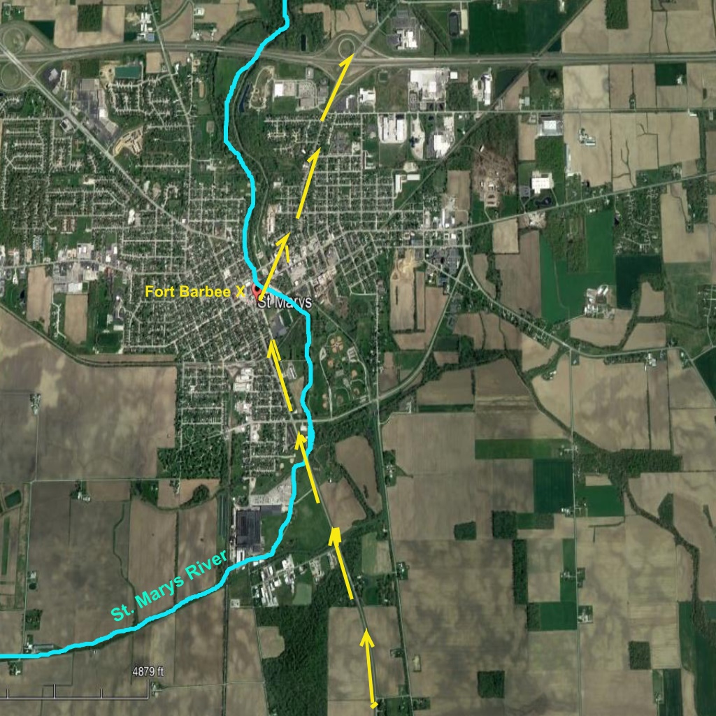
My break came when I came across an entry in the Schillinger Journal. But first a little geography lesson. Notice in the map below that Upper Sandusky is actually south of Sandusky and Upper Arlington, Oh is actually north of Arlington, Oh. In 1812, anything "below" a particular site was actually north of it and site "above" the site was south of it. We see that in Schillinger's journal where he wrote that the indian village of Wapakoneta was "8 miles above us," and the Kentuckians camped in the commons "1/2 mile "below" the fort. These are key points to keep in mind as you read what follows.

On February 28, 1813,Schillinger wrote: "Cross,d the creek and camp,d on the bank opposite the garrison." A few weeks later Captain Rober McKee wrote, "Arrived at St. Marys about 9 oclock and campt about a quarter mile above the fort on the bank of the river on high ground."

Waynes old fort (1796) had been abandoned by 1812 so when Schillinger and McAfee wrote that they'd camped "across the creek" and "above the fort" what the men were saying was the area where they camped was south of Ft. Barbee and on the other side of the east side of the St. Marys River. The question then became where exactly was it located?
A Clue
One clue is Schillinger's use of the word "creek." In his journal, Schillinger was very specific about identifying creeks and rivers. Example, he used the term "river" for waterways that are in fact rivers, i.e., Mad River, St. Mary's River and Auglaize River. When he mentioned creeks, they were in fact creeks, i.e. 6 mile creek, Honey Creek and Loramies creek. The most important clue was his Feb. 27th entry where he wrote, "Moved on to St. Marys 12 miles crossed the creek Note that he doesnt' say he crossed a river, he wrote that he "crossed the creek."
From this we can gather that when Schillinger and other troops moving north reached the point on the road from Ft. Loramies (Rt. 66) where troops going northwest toward Kekionga actually crossed the St. Marys River, Schillingers company veered to the northeast and crossed what is today called the "East branch of Clear Creek (see map below). In other words, it appears as though Schillinger and the other northbound troops didn't cross the St. Marys River twice, they didn't cross it at all.


From this we can gather that when Schillinger and other troops moving north reached the point on the road from Ft. Loramies (Rt. 66) where troops going northwest toward Kekionga actually crossed the St. Marys River, Schillingers company veered to the northeast and crossed what is today called the "East branch of Clear Creek (see map below). In other words, it appears as though Schillinger and the other northbound troops didn't cross the St. Marys River twice, they didn't cross it at all.
The Lost Campsite
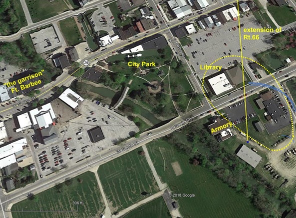
The next mystery was if the northbound troops camped on the east side of the St. Marys, where was it. The answer to that may be in what Capt. McAfee wrote, "camp,d about a quarter mile above the fort on the bank of the river on high ground." The "fort" would have been Fort Barbee. So now we know that the area was on the east side of the river, 1/4mile south of the fort on high ground. The picture shows cross section of the terrain 1/4 mile "above" the fort.

Notice in the picture below, if you extend the leg of route 66 entering town and extend it (blue line), it terminates at the approximate site of what may have been the main camping area for north bound troops. It meets the criteria presented by Schillinger and McAfee in that it is across the river from the garrison, its about 1/4 mile above the garrison and its on high ground.


Conclusion
Based on the information provided above, I propose that the campsite for northbound troops during the War of 1812 encompassed the area shown within the dotted yellow line below.


